Knowing the USDA planting zones is quite important to every gardener or farmer in the United States. Basically, the zones provide very vital information regarding the climatic conditions of the different parts within the region, hence guiding a person on the type of plants which will perform well in that particular place. It explains what the USDA planting zones are, why they are important, how you can determine your zone, and most importantly, how you can make an informed decision during gardening.
What Are USDA Planting Zones?
The Plant Hardiness Zone Map is a creation of the USDA, and more vernacularly, it is called USDA planting zones or hardiness zones. In the USDA map, there are 13 overall divisions of the United States where, in each division, there is a slight difference in the average annual minimum winter temperature. The fundamental idea regarding these zones is basically to tell the gardener and the farmer which plants are likely to grow locally.
Understanding the Zones
Each zone is a 10°F difference in the average annual minimum temperature. Example:
- Zone 1 Below -50°F
- Zone 2 -50°F to -40°F
- Zone 3 -40°F to -30°F
- Zone 4 -30°F to -20°F
- Zone 5 -20°F to -10°F
- Zone 6 -10°F to 0°F
- Zone 7 0°F to 10°F
- Zone 8 10°F to 20°F
- Zone 9 20°F to 30°F
These zones have further “a” and “b” subzones that break the temperature range down even further.
Why Are USDA Planting Zones Important?
1. Selection of Plants:
Knowing a USDA planting zone readily tells one the range of plants best adapted to local growing conditions. Those that are not hardy to a certain zone will not survive the winter, for instance; on the other hand, those falling within the range of your zone are likely to perform well.
2. Successful Gardening:
Choosing the right type of plants for your zone enhances your chances of success. Plants are far healthier, require less care, and produce much better if they are more adapted to the climactic region they are put in.
3. Risk Mitigation:
Zone planting helps to reduce the risks associated with adverse climatic conditions that can cause loss, thereby saving valuable time, effort, and money spent on raising a garden.
4. Biodiversity:
Planting a variety of native species within your zone can foster local biodiversity. This will benefit native fauna like very important pollinators such as bees and butterflies.
How to Know Your USDA Planting Zone
It is fairly easy to determine your USDA planting zone. You can do it with the help of the USDA Plant Hardiness Zone Map, which is available on their website. Step one to find your zone :
View the Map Log onto the Internet and go to the USDA Plant Hardiness Zone Map.
1. Enter Your Zip Code: Many of the online versions will ask one to enter their zip code to find one’s zone quickly.
2. Locate Your Position: You can also determine exactly what your zone is by merely finding out where you are geographically on the map.
3. Know Your Zone: Once you have your zone, know the approximate range of average minimum temperatures your zone covers. This way you can make better choices on your plant selection.
The Use of USDA Plant Hardiness Zones in Landscaping
1. Plant Selection:
Suppose you are out on a plant buying spree; then always look at the plant label or description of the plant for the hardiness zone. Hence, it is pretty prudent to buy recommended plants for your zone to make sure that they withstand and fight through the winters’ chills and chalices with the chill that envelops your area.
2. Know Your Zone for Planning Your Garden:
Observe the zone information to plan the design of your garden. Next, group together plants having the same temperature requirements, going nicely with and staying healthy together in your garden.
3. Seasonal Adjustments:
Be familiar with the growing season of your zone. This will definitely help you in the timing of the crops planting and harvest so that you get maximum efforts from the growth and productivity of your plants.
4. Microclimates:
Keep in mind that microclimates in your zone can affect the performance of plants. Elevation, proximity to large bodies of water, and even urban heat islands can change the temperature within the same exact zone.
Challenges and Limitations
Although the USDA hardiness zones do have some merit, they are only part of the picture. They are based on the average minimum winter temperatures and don’t reflect anything else that may bear on how well a plant is going to do in your area.
- Summer Temperatures—Some plants are cold hardy enough to survive the winter temperatures of a zone, yet are unable to tolerate its summer heat.
- Soil Conditions: Soil type, pH and drainage are extremely important conditions to plant health, and these the USDA zones do not account for.
- Humidity and Precipitation: Although the moisture levels, coupled with rain patterns are very essential to plant health, these cannot be portrayed through the zone map.
- Wind and Sun: Different amounts of sun exposure along with exposure to wind can bring about great differences in plants at significant levels concerning growth and survival.
Summary of Hardiness Zones by State
All states offer a range of zones because of diversified landscapes and related climate. Here is a general summary of the planting zones by state:
Alabama
Zones 7a through 9a: While the northern part of Alabama represents zone 7a, southern areas span up to zone 9a. From mountains to coastal areas, topography varies in the state.
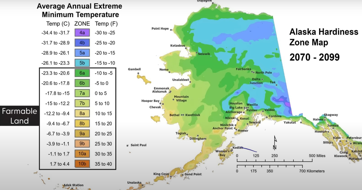
Alaska
1a to 8b: Alaska has the most variation, with very large size and diverse climate. Interior regions have gone as low as 1a, but coastal areas in the southern part are at 8b.
Arizona
4b to 10b: Northern Arizona parts are around 4b, as the region around the Grand Canyon, but the southern part, like Phoenix and Tucson, are in 9b and 10b.
Zones 6b to 8a: State is mostly 7a and 7b but goes up to 6b in the north and down to 8a in the south.
California
Zones 5a to 11a: The state of California has almost every climate so its hard zoning varies greatly. On the coast and parts of SoCal, it can get as high as 11a, with high elevations and the northern parts of the state going as low as 5a.
Colorado
Zones 3a to 7a: The Rocky Mountains sustain a quite wide span of zones, from mountains in 3a to urban areas like Denver in 5b to 6a.
Connecticut
Zones 5b to 7a: Much of Connecticut is in 6a and 6b, but area closest to the ocean reach 7a.
Delaware
Zones 7a to 7b: Delaware is relatively constant; most of it is 7a, except for the coastal 7b.
Florida
Zones 8a to 11: North Florida falls in 8a, with the far south of the state and the Keys climbing to 11, and boasting a tropical climate.
Georgia
Zones 6a to 9: North Georgia, along with the Appalachian Mountains, falls in 6a to 6, and South Georgia falls in 9 and up.
Hawaii
Zones 10a to 12b: Hawaii’s tropical climate places it around some of the highest zones, with much of the state in zones 10a to 12b.
Idaho
Zones 3b to 7b: This state ranges from zone 3b in the higher elevations to zone 7b in lower, southern areas.
Illinois
Zones 5a to 7a: Northern Illinois, including Chicago, falls in zone 5a, while southern Illinois can go as high as zone 7a.
Indiana
5b to 6b: Indiana is mostly in zones 5b to 6b, although local microclimates can raise or lower the actual zone rating.
Iowa
4a to 5b: The state is mainly in zone 5a, but it has a northern portion reaching zone 4a.
Kansas
5b to 7a: Kansas ranges from zone 5b at the north end to zone 7a in the south.
Kentucky
Zones 6a to 7b: The better part of the state falls within the 6b and 7a zones. The rest of the southern parts are on the 7b zone.
Louisiana
Zones 8a to 9b: The northern part of the state is in the 8a zone, and the southern part is in the 9b zone.
Maine
Zones 3b to 6a: Most of the better part of the state is in the 3b zone, while the
5b to 8a: Western Maryland is in 5b, and the eastern part—that includes the Chesapeake Bay area—is in 8a.
Massachusetts
5a to 7b: The majority of the state lies in 5b to 6b, but some coastal areas reach up to 7b.
Michigan
3b to 6b: Northern Michigan, including the Upper Peninsula, falls in zone 3b. Southern Michigan raises to 6b.
Minnesota
Zones 3a to 5b: Most of the state lies in 3b to 4b zones while the southern region is in 5a.
Mississippi
Zones 7b to 9a: The northern region is in the 7b zone while the south is in the 9a.
Missouri
Zones 5b to 7a: The state has a variation from 5b in the north to the south in zone 7a.
Montana
Zones 3a to 6a: Montana’s extensive range varies from zone 3a in the mountains to 6a across the valleys.
Nebraska
Zones 4a to 6b: Most part of the state falls in zones 5a to 5b, and the far western part is reaching zone 4a.
Nevada
Zones 4a to 10a: Northern Nevada can be found in zone 4a, but the southern region, including Las Vegas, can be found in zone 10a.
New Hampshire
Zones 3b to 6a: Northern New York falls in zone 3b, while southern parts are in zone 6a.
New Zealand
Zones 9b to 13b: It varies between zone 9b in the north and 13b in the south, corresponding to those latitudes in the northern hemisphere.
North
Zones 2a to 14b: It varies from zone 2a in the north to 14b in the south, corresponding to those latitudes in the northern hemisphere
3b to 7b: Northern New York, which includes the Adirondacks, is in zone 3b, whereas New York City reaches zone 7b.
North Carolina
6a to 8b: The state ranges from zone 6a in the Appalachian Mountains to zone 8b in the coastal plain.
North Dakota
3a to 4b: Most of the state is included in zones 3a to 4b, reflecting cold winters.
Ohio
Zones 5a to 6b: Ohio is mostly in zones 5b to 6a, with some variation across the state.
Oklahoma
Zones 6a to 8a: Northern Oklahoma is in zone 6a, while southern parts reach zone 8a.
Oregon
Zones 4b to 9b: The state ranges from zone 4b in the eastern high deserts to zone 9b in the coastal regions.
Pennsylvania
Zones 5a to 7b: Northern Pennsylvania is in zone 5a, and the southeast corner, which includes Philadelphia, is up to zone 7b.
Rhode Island
Zones 6a to 7a: The state is relatively homogenous, mostly in zones 6b to 7a.
South Carolina
Zones 7a to 9a: Northern South Carolina is in zone 7a, and the coastal areas are up to zone 9a.
South Dakota
Zones 3b to 5b: Predominantly, the state is in the zones 4a to 5b, with difference in elevation.
Tennessee
Zones 6a to 8a: It goes from zone 6a in the eastern mountains to zone 8a in the southwestern areas.
Texas
Zones 6a to 10b: The huge range of Texas slopes across from zone 6a in the northern Panhandle all the way down to zone 10b in the southern tip.
Conclusion
Knowing the USDA planting zones is one of the best things about any gardening or farming that succeeds within the United States. Knowing your hardiness zone will give you an idea of the plants that are more suitable for your local climate and increase the chances of a garden in bloom and of use. While USDA hardiness zones are very good starting points, there are other things to consider in choosing the best for your garden, like soil condition, moisture levels, and microclimate. With such knowledge at hand, you will be able to develop an even more gorgeous and hardy garden, a potential big boon to your outdoor space, biodiversity, and the environment generally.